Satellite Data Services Market Share, Size, Trends, Industry Analysis Report, By Application (Scientific, Administrative, Commercial); By Industry Vertical (Defense & Security, Energy & Power, Agriculture, Environmental, Engineering & Infrastructure, Marine, Others); By Region; Segment Forecast, 2021 - 2028
- Published Date:Oct-2021
- Pages: 115
- Format: PDF
- Report ID: PM2032
- Base Year: 2020
- Historical Data: 2016 - 2019
Report Outlook
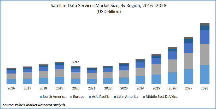
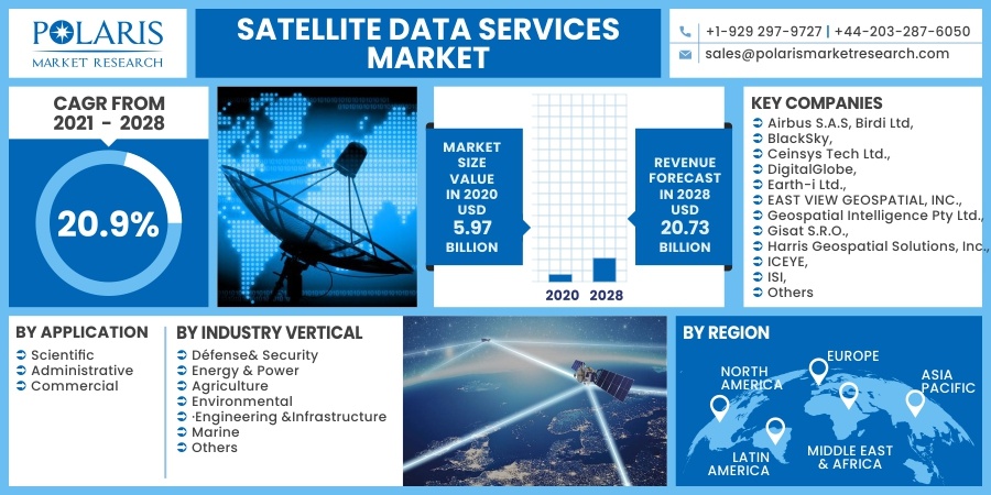
The global satellite data services market was valued at USD 5.97 billion in 2020 and is expected to grow at a CAGR of 20.9% during the forecast period. The growth of the product data services market is driven by the surge in innovations in the field of space and satellite services to leverage earth observation and disaster management, coupled with the robust growth in penetration of artificial intelligence and cloud computing in the space sectors, which is now required to offer insights on earlier inaccessible factors such as industrial, economic, and social processes.
 Know more about this report: request for sample pages
Moreover, the data services without satellite networks can only broadcast signals for navigation, and there is no two-way communication. However, the emergence of technology or networking in such data services is contributing the significant market development. This, in turn, is providing lucrative thrust to the data services market all over the world. Furthermore, the rising need for earth observation satellites and increasing urban accumulation and monitoring urbanization of neighboring areas to facilitate smart city planning and implementation is further expanding the global implementation of the services which in turn will boost the product data services market growth.
The ongoing COVID-19 pandemic has rushed the world, with several industries putting efforts to stay afloat. The business and government authorities involved with space are further reacting distinctly to the new situation. However, in the current outbreak of a pandemic, satellite imagery and analytics firms witness a growing interest in remote monitoring of data service facilities that have become harsher to reach as of travel restrictions imposed by different governments internationally.

Know more about this report: request for sample pages
Industry Dynamics
Growth Drivers
The proliferation of the data services market is rising at a significant pace rate considering the global scenario. The surging trend to utilize satellite data across different industry verticals has created a new prospect for product data services market growth worldwide. The current, sophisticated services are mainly growing because of their ability to store all data and provide the same to respective operators.
It further enables end-users to retrieve real-time satellite imagery supply on mobile devices, owing to the attractiveness of tools such as Google Earth, which is additionally gaining a competitive advantage to the satellite data services market growth. Furthermore, the increased implementation of artificial intelligence (AI) and machine learning (ML) in the space sector has generated several potential service providers to deliver AI and ML integrated solutions. Hence, it is expected to strengthen the trend for the services in developed and emerging markets.
Additionally, the proliferation of cloud computing has been expanding continually in such services, coupled with satellite imagery, facilitating researchers to gain access to imagery data from remote locations. Cloud technology also allows organizations to retrieve historical data, which may be utilized for analysis.
Report Segmentation
The market is primarily segmented based on application, industry vertical, and region.
|
By Application |
By Industry Vertical |
By Region |
|
|
|
Know more about this report: request for sample pages
Insight by Application
Based on the application market segment, the administrative segment is expected to dominate the satellite data services market during the foreseen period. The is partly due to the government and non-government agencies are the frontrunner in implementing satellite-based imagery and insights for numerous administrative purposes, including land management, cadastral surveying, and infrastructure monitoring.
Furthermore, the rise in incorporation of big data technology and satellite imagery allows organizations to map the development of urban areas rapidly, the resources flow and take essential administrative measures. Apart from this, the adoption of such services increased as a pre-requisite for advancing G.I.S. maps and scrutinizing data shown in a satellite image, and hence, is creating a huge implementation of such satellite data services globally.
Insight by Industry Vertical
The environmental segment is expected to witness large market revenue in the global market due to the growing requirement for high-resolution earth images to precisely map wildlife populations, detect deforestation, and track illegal mining trends has offered considerable growth prospects across the environmental sector.
Moreover, meteorologists' increased usage of satellite imagery to monitor recent climate changes directly and take essential remedial measures impetus the market growth. In addition, federal agencies have further begun developing missions to utilize satellite-based LiDAR to map the height and structure of forest covers and map carbon biomass and storage above the ground level. This, in turn, is expected to gain a significant profit share that accelerates the growth of the global satellite data services market.
Geographic Overview
Geographically, North America dominated the global market accounted for the largest share in terms of revenue due to the significant presence of various observation satellite makers and rising investments by the National Aeronautics and Space Administration (NASA) in the R&D of innovative products in the region. Additionally, the design of the new National Space Strategy facilitates the administration related to government authorities to collaborate with key manufacturers in the commercial sector in a way that they can form an efficient defense system in contradiction of threats caused by space-bound attacks, which is further expanding the market growth at a rapid pace considering the global scenario.
The United States and Canada are further anticipated to register the robust growth in terms of strategic initiatives and product and services expansion that will prolong the application of such solutions to streamline activities related to satellites across these countries. As a result, in June 2020, U.S.-based Planet Labs unveiled a new cloud-based dashboard and supplementary API for satellite imagery solutions. Partnering businesses will be capable of utilizing innovative tools to automate satellite imagery task requirements. Such initiative is expected to bolster the region's data services market growth.
Competitive Insight
Some of the major market players operating in the global market include Airbus S.A.S, Birdi Ltd, BlackSky, Ceinsys Tech Ltd., DigitalGlobe, Earth-i Ltd., EAST VIEW GEOSPATIAL, INC., Geospatial Intelligence Pty Ltd., Gisat S.R.O., Harris Geospatial Solutions, Inc., ICEYE, ISI, LAND INFO Worldwide Mapping, LLC, Planet Labs, Inc., Planetobserver, Satpalda Geospatial Services, SPECTIR, Trimble Inc., and Ursa Space Systems, Inc.
Satellite Data Services Report Scope
|
Report Attributes |
Details |
|
Market size value in 2020 |
USD 5.97 billion |
|
Revenue forecast in 2028 |
USD 20.73 billion |
|
CAGR |
20.9% from 2021 - 2028 |
|
Base year |
2020 |
|
Historical data |
2016 - 2019 |
|
Forecast period |
2021 - 2028 |
|
Quantitative units |
Revenue in USD billion and CAGR from 2021 to 2028 |
|
Segments covered |
By Application, By Industry Verticals, By Region |
|
Regional scope |
North America, Europe, Asia Pacific, Latin America, Middle East & Africa |
|
Key Companies |
Airbus S.A.S, Birdi Ltd, BlackSky, Ceinsys Tech Ltd., DigitalGlobe, Earth-i Ltd., EAST VIEW GEOSPATIAL, INC., Geospatial Intelligence Pty Ltd., Gisat S.R.O., Harris Geospatial Solutions, Inc., ICEYE, ISI, LAND INFO Worldwide Mapping, LLC, Planet Labs, Inc., Planetobserver, Satellite Imaging Corporation, Satpalda Geospatial Services, SPECTIR, Trimble Inc., and Ursa Space Systems, Inc. |
