Remote Sensing Services Market Share, Size, Trends, Industry Analysis Report, By Application (Agriculture, Engineering & Infrastructure, Environmental & Weather, Energy & Power, Transportation & Logistic, and Others); By Platform; By Technology; By Region; Segment Forecast, 2024 - 2032
- Published Date:Jan-2024
- Pages: 114
- Format: PDF
- Report ID: PM3486
- Base Year: 2023
- Historical Data: 2019-2022
Report Outlook
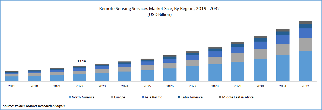
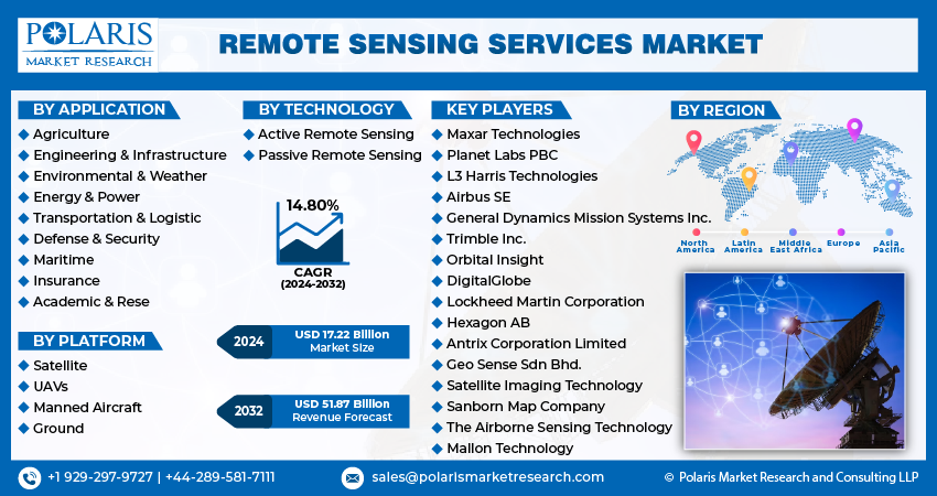
The global remote sensing services market was valued at USD 15.04 billion in 2023 and is expected to grow at a CAGR of 14.80% during the forecast period. Rapid increase in the number of earth observation projects by various large space agencies around the world and widespread adoption of remote sensing services or technology for gathering information regarding the earth’s surface and analyze the physical characteristics by using emitted and reflected light from satellites and aircrafts, are major factors driving the growth of the global market.

To Understand More About this Research: Request a Free Sample Report
In addition, the surge in the use of remote sensing data in defense applications for generating geographic information regarding numerous applications such as flight stimulation, mission planning, and air-defense planning, is further likely to fuel the demand for these services in defense sector all over the world. For instance, in December 2022, China, sent new remote-sensing satellite into the space from its Xichang Satellite Launch Center. The satellite named ‘Yaogan-36’ was through a Long March-2D carrier rocket.
Moreover, the increasing adoption of Internet of Things (IoT) technology in the agriculture sector, as it uses remote sensors, computer imaging, drones, and robots to efficiently monitor crops and provide data to farmers for improved farm management, as it enables farmers to monitor the crops from an analytical dashboard, is opening huge potential for the market. However, the need for heavy initial investments in the manufacturing of components required in performing remote sensing services and various standards set by regulatory organizations, that is required to be followed by market players, are among the factors expected to limit and hinder the market growth.
The outbreak of the COVID-19 pandemic has moderately impacted the growth of the remote sensing services market. With the rapid emergence of deadly coronavirus, many countries have imposed restrictions and regulations on several business activities but there had been a surge in the adoption of these services by public health agencies, administrators, and policy makers, to effectively understand the pattern of the outbreak in real-time to identify at-risk populations and planning targeted intervention.

Industry Dynamics
Growth Drivers
High technological advancements and improvements in geospatial imagery analytics through the introduction to advanced technologies such as artificial intelligence and big data, to perform numerous tasks faster and with minimal errors, are primary factors boosting the remote sensing services market growth globally. The introduction to big data technology has boosted growth opportunities, as it can process large quantities of data in the possible shortest time, which is fueling the growth of the market.
Furthermore, the growing need for real-time data across the globe, that ensures that the information supply matches the overall intervention capability of end-user verticals along with the increasing requirements of decision-makers for up-to-date environmental information to effectively manage natural resources, which in turn, creating huge demand and growth opportunities for the global market.
Report Segmentation
The market is primarily segmented based on application, platform, technology, and region.
|
By Application |
By Platform |
By Technology |
By Region |
|
|
|
|
To Understand the Scope of this Report: Speak to Analyst
Defense & security application segment accounted for largest market share in 2022
The growth of the segment can be highly accelerated to widespread adoption of highly developed and innovated technology services especially in developed countries like US, Canada, Germany, and France, with an aim to effectively monitor and prevent descriptive and criminal activities. In addition, several emerging economies including China, India, and Russia are significantly focusing on utilizing satellite images for various defense applications, thereby propelling the demand and growth of the segment market.
Moreover, the monitoring maritime and land surveillance activities across the globe have significantly gained importance in the recent past years due to the growing advancements in satellite technologies and availability of high-speed data services.
UAVs segment is expected to witness fastest growth over the forecast period
The UAVs segment is projected to grow at a high CAGR during the anticipated period, which is mainly driven by exponential growth and rapid development of UAVs as an innovative remote sensing platform along with the growing advances in technologies and data systems across the globe. In addition, the extensive rise in the prevalence of using drones with improved remote sensors mainly for the site characterization along with the increasing technological developments such as enhanced battery efficiency, increased data storage capacity, and compact & lightweight onboard computers are also likely to fuel the overall demand and growth of the market.
The satellite segment led the industry market with significant revenue share in 2022, which is highly accelerated to rising earth observation projects across several major space agencies including NASA among others coupled with growing adoption of several satellite-based images for weather forecasting across the globe.
Passive remote sensing segment held the significant market share
Passive segment held the maximum market revenue share in 2022, which is largely attributed to its capabilities to effectively measure the sunlight from the earth’s surface to determine and monitor the characteristics of the earth surface. This technology also offers high-quality satellite pictures and being largely used for numerous observation applications
Active segment is anticipated to register fastest growth over the next coming years, mainly due to its widespread adoption across the globe, as it helps overcome the drawbacks associated with passive remote sensing including analyzing surface characteristics in dark and night view. Moreover, the growing utilization of this technology to measure ice & sea surface topography, forest structure among many others, are also projected to boost the segment market.

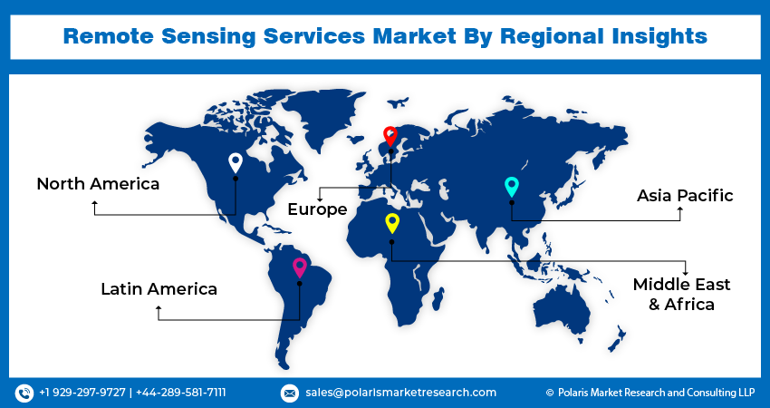
North America region dominated the global market in 2022
North America region dominated the global market with healthy market share, in 2022. The growth of the regional market can be highly attributed to growing implementation of advanced technology in remote sensing and its wide range of applications along with the high focus on specializing remote sensing services and supporting various types of high-end civil, military, and commercial customers. Additionally, the extensive rise in the adoption of these services across precision farming applications, as it provides water resource managing tools to reduce the dry spells impact and fulfill the crops irrigation needs, which in turn, further propelling the market growth.
Asia Pacific region is anticipated to be the fastest growing region on account of continuous surge in the demand and adoption of innovative earth observation technologies for several infrastructure development applications and increasing government favorable initiatives for urban infrastructure development like India’s Smart City Mission and many others.

Competitive Insight
Some of the major players operating in the global market include Maxar Technologies, Planet Labs PBC, L3 Harris Technologies, Airbus SE, Trimble Inc., Orbital Insight, General Dynamics Mission Systems Inc., DigitalGlobe, Lockheed Martin Corporation, Hexagon AB, Antrix Corporation Limited, Geo Sense Sdn Bhd., Satellite Imaging Technology, Sanborn Map Company, The Airborne Sensing Technology, and Mallon Technology.
Recent Developments
- In August 2022, China announced the launch of its remote sensing satellite into space, for the land resources management, environment monitoring, & agricultural resources survey. It was the 434th flight mission of the country’s that comes a day after the China sent into space their new Chuangxin-16 satellite for scientific experiments.
- In June 2022, Planet Labs announced that the company has entered into a strategic agreement with Bayer, where Planet Labs will provide its SkySat data and professional services to Bayer for creating collaborative solutions, that help in optimizing seed solution, enhance the efficiency of supply chain, and will further support the sustainable agriculture.
Remote Sensing Services Market Report Scope
|
Report Attributes |
Details |
|
Market size value in 2024 |
USD 17.22 billion |
|
Revenue forecast in 2032 |
USD 51.87 billion |
|
CAGR |
14.80% from 2023– 2032 |
|
Base year |
2023 |
|
Historical data |
2019– 2022 |
|
Forecast period |
2024– 2032 |
|
Quantitative units |
Revenue in USD billion and CAGR from 2024 to 2032 |
|
Segments covered |
By Application, By Platform, By Technology, By Region |
|
Regional scope |
North America, Europe, Asia Pacific, Latin America; Middle East & Africa |
|
Key companies |
Maxar Technologies, Planet Labs PBC, L3 Harris Technologies, Airbus SE, Trimble Inc., Orbital Insight, General Dynamics Mission Systems Inc., DigitalGlobe, Lockheed Martin Corporation, Hexagon AB, Antrix Corporation Limited, Geo Sense Sdn Bhd., Satellite Imaging Technology, Sanborn Map Company, The Airborne Sensing Technology, and Mallon Technology. |
FAQ's
The remote sensing services market report covering key segments are application, platform, technology, and region.
Remote Sensing Services Market Size Worth $51.87 Billion By 2032.
The global remote sensing services market is expected to grow at a CAGR of 14.7% during the forecast period.
North America is leading the global market.
key driving factors in remote sensing services market are increase in advancements in remote sensing technologies.
