

LiDAR Drone Market Size, Share, Trends, Industry Analysis Report: By Application, Component, Drone Type (Fixed-Wing Drones, Multirotor Drones, and Hybrid Drones), and Region (North America, Europe, Asia Pacific, Latin America, and Middle East & Africa) – Market Forecast, 2025–2034
- Published Date:Jan-2025
- Pages: 129
- Format: PDF
- Report ID: PM1678
- Base Year: 2024
- Historical Data: 2020-2023
LiDAR Drone Market Overview
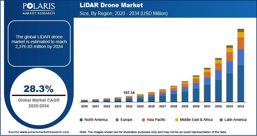
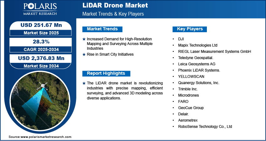
The global LiDAR drone market size was valued at USD 197.14 million in 2024 and is expected to reach USD 251.67 million by 2025 and USD 2,376.83 million by 2034, exhibiting a CAGR of 28.3% from 2025 to 2034.
The global LiDAR drone market is rapidly gaining traction as a transformative tool for applications requiring precise topographical mapping, 3D modeling, and geospatial analytics. Light sensor and ranging (LiDAR) technology integrated with drones offers unparalleled accuracy in capturing spatial data, making it invaluable across industries such as agriculture, construction, mining, environmental monitoring, and disaster management. LiDAR-equipped drones create highly detailed maps of terrains, structures, and vegetation, even in challenging or inaccessible environments, by using laser pulses to measure distances.
Since 2020, advancements in drone autonomy, lightweight LiDAR sensors, and cloud-based data processing have accelerated the adoption of LiDAR drones globally, thereby contributing to the market growth. Increasing investments in smart city projects, defense modernization, and sustainable land management are also boosting the LiDAR drone market demand. For instance, a November 2023 report by the World Economic Forum highlighted the Government of India’s SVAMITVA Scheme, which involves mapping land in 660,000 villages using drones with LiDAR technology. This initiative aims to improve rural property rights and support economic development through accurate land records. Further, LiDAR drones are set to revolutionize geospatial data collection as industries shift toward automation and precision analytics, impacting market development favorably.
To Understand More About this Research: Request a Free Sample Report
LiDAR Drone Market Growth and Trend Analysis
Increased Demand for High-Resolution Mapping and Surveying Across Multiple Industries
LiDAR drones offer unmatched precision and efficiency in capturing detailed terrain data, making them indispensable for sectors such as construction, agriculture, forestry, mining, and urban planning. These drones enable rapid data acquisition in challenging terrains and large areas, reducing the time and cost compared to traditional surveying methods. The growing reliance on accurate geospatial data for infrastructure development, environmental monitoring, and disaster management propels their adoption which is further driving the LiDAR drones market growth. Additionally, advancements in LiDAR technology and drone capabilities enhance resolution and range, meeting the rising industry demands for sophisticated mapping solutions. For instance, in October 2024, YellowScan partnered with Argosdyne, whose UAV has achieved C2 Class certification. This certification allows closer operation in populated areas, enhancing aerial LiDAR services with increased safety and precision for surveying and mapping projects. Thus, the increased demand for high-resolution mapping and surveying across multiple industries is a major driver of the LiDAR drone market expansion.
Rising Smart City Initiatives
The rising smart city initiatives such as the integration of advanced technologies plays a vital role in transforming urban landscapes into efficient, sustainable, and innovative smart cities. For instance, in January 2022, Peachtree Corners became the first smart city in the US to deploy LiDAR technology for its infrastructure. Autonomous vehicles operate alongside regular traffic and communicate with city-owned Ouster LiDAR units at intersections. In addition, LiDAR drones provide high-precision mapping and 3D modeling, enabling authorities to design and monitor smart city components such as transportation networks, utilities, and green spaces. Their ability to quickly survey large areas and deliver accurate data supports the development of digital twins, essential for smart city management. With governments worldwide investing heavily in smart city programs to improve urban living standards and resource management, LiDAR drones have become a critical tool in modern urban development, thereby driving the LiDAR drone market revenue.
LiDAR Drone Market Segment Insights
LiDAR Drone Market Outlook Based on Application
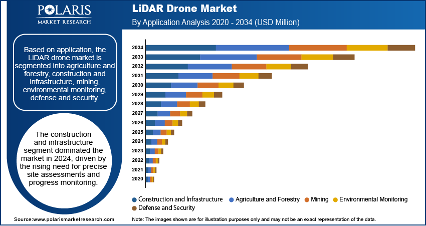
The global LiDAR drone market, based on application, is segmented into agriculture and forestry, construction and infrastructure, mining, environmental monitoring, and defense and security. The construction and infrastructure segment dominated the market with the largest revenue share in 2024, driven by the rising need for precise site assessments and progress monitoring. The ability of LiDAR drones to collect accurate data even in congested urban environments ensures streamlined planning and minimizes errors, making them indispensable for modern infrastructure projects.
LiDAR Drone Market Assessment Based on Drone Type
The global LiDAR drone market, based on drone type, is segmented into fixed-wing drones, multirotor drones, and hybrid drones. The multirotor drones segment led the market in 2024, as multirotor drones offer superior maneuverability and stability for detailed surveys in confined spaces. These drones are particularly favored for environmental monitoring and urban development projects. The versatility of multirotor drones in carrying various payloads, including lightweight LiDAR sensors, enhances their appeal. Their cost-effectiveness compared to fixed-wing drones also broadens their accessibility, particularly in developing markets.
LiDAR Drone Market Regional Analysis
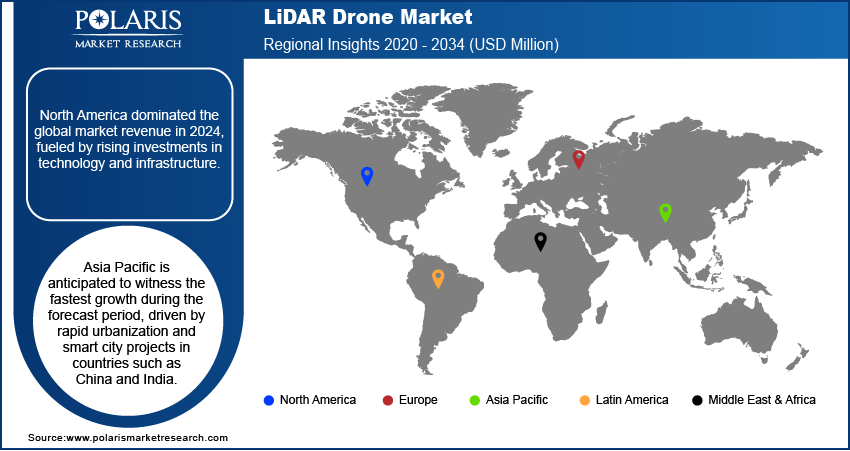
By region, the report provides the LiDAR drone market insights into North America, Europe, Asia Pacific, Latin America, and the Middle East & Africa. North America accounted for the largest market revenue share in 2024, fueled by rising investments in technology and infrastructure. The US leads the regional market, driven by the extensive adoption of LiDAR drones in sectors such as defense, agriculture, and construction. Government initiatives to modernize infrastructure and enhance disaster management capabilities further support the market growth in the US. For instance, in 2024, the US Geological Survey (USGS) recommended 14 LiDAR partnership projects across 13 states. According to USGS, these initiatives are expected to generate over 99,000 square miles of public domain LiDAR point cloud data and associated elevation products, particularly enhancing the data repository of 3DEP.
The Asia Pacific LiDAR drone market is projected to register the fastest growth during the forecast period, driven by rapid urbanization and smart city projects in countries such as China and India. China leads the region due to its robust manufacturing base, technological advancements, and government-backed infrastructure projects. For instance, the Belt and Road Initiative, a global infrastructure development initiative launched by the Chinese government in 2013, emphasizes precise topographical assessments, making LiDAR drones critical. In addition, increasing environmental monitoring efforts drive market development in the region.
LiDAR Drone Market – Key Players and Competitive Landscape
Major market players are investing heavily in research and development in order to expand their offerings, which will help the LiDAR drone market grow even more. The top 15 companies in the market dominate through innovation, extensive distribution networks, and strategic partnerships. Market leaders such as DJI and Velodyne LiDAR leverage their advanced technologies and economies of scale to maintain a competitive edge. For example, DJI's integration of AI-driven analytics into its drones enhances data accuracy and usability. Velodyne’s focus on lightweight and cost-effective LiDAR sensors widens accessibility. Regional players such as YellowScan and Phoenix LiDAR Systems specialize in niche applications, such as forestry and environmental monitoring, catering to specific customer needs. Companies like Trimble Inc. and Leica Geosystems differentiate through comprehensive software solutions, ensuring seamless data analysis and integration. This combination of innovation, adaptability, and customer focus allows these companies to retain leadership in a competitive market.
Mapix Technologies Ltd is a provider of LiDAR solutions specializing in the supply of advanced LiDAR sensors, software, and integrated systems for various industries. Based in the United Kingdom, the company offers customized LiDAR drone solutions designed for applications such as surveying, mapping, forestry, and infrastructure management. Mapix Technologies works closely with its clients to deliver precise and high-resolution data for accurate decision-making. The company is known for its customer-focused approach and strong partnerships with industry-leading manufacturers, ensuring access to the latest LiDAR technologies. Mapix also provides training and technical support to maximize the utility of its products.
YellowScan, headquartered in France, is a globally recognized innovator in lightweight, fully integrated LiDAR solutions for UAVs (Unmanned Aerial Vehicles). YellowScan’s LiDAR systems are widely used across industries such as forestry, mining, environmental research, and civil engineering. The company’s product portfolio includes compact and robust systems that integrate seamlessly with drones, enabling efficient data collection even in challenging terrains. YellowScan by advancing technology provides real-time data processing, ensuring that clients achieve actionable insights quickly.
List of Key Companies in LiDAR Drone Market
- DJI
- Mapix Technologies Ltd
- RIEGL Laser Measurement Systems GmbH
- Teledyne Geospatial.
- Leica Geosystems AG
- Phoenix LiDAR Systems.
- YELLOWSCAN
- Quanergy Solutions, Inc.
- Trimble Inc.
- Microdrones
- FARO
- GeoCue Group
- Delair.
- Aerometrex
- RoboSense Technology Co., Ltd
LiDAR Drone Industry Developments
May 2022: Flyability, a Switzerland-based company that designs and manufactures drones for industrial inspections and analysis, unveiled the Elios 3. According to Flyability, Elios 3 is the world’s first collision-tolerant drone equipped with a LiDAR sensor for indoor 3D mapping for Industry 4.0.
June 2021: Velodyne LiDAR, Inc. introduced the next generation of its Velabit LiDAR sensor. The company stated that the next generation of its Velabit LiDAR sensors aims to address the cost, safety, and design challenges of automobile, sidewalk, industry, and UAV mapping.
February 2021: Phoenix LiDAR Systems (PLS) announced its strategic partnership agreement with Nordic Unmanned. According to PLS, the partnership will focus on providing industry-leading products and services in the unmanned aerial market.
LiDAR Drone Market Segmentation
By Application Outlook (Revenue – USD Million, 2020–2034)
- Agriculture and Forestry
- Construction and Infrastructure
- Mining
- Environmental Monitoring
- Defense and Security
By Component Outlook (Revenue – USD Million, 2020–2034)
- LiDAR Sensors
- Cameras
- Navigation Systems
- Drone Platforms
- Software Solutions
By Drone Type Outlook (Revenue – USD Million, 2020–2034)
- Fixed-Wing Drones
- Multirotor Drones
- Hybrid Drones
By Regional Outlook (Revenue – USD Million, 2020–2034)
- North America
- US
- Canada
- Europe
- Germany
- France
- UK
- Italy
- Spain
- Netherlands
- Russia
- Rest of Europe
- Asia Pacific
- China
- Japan
- India
- Malaysia
- South Korea
- Indonesia
- Australia
- Vietnam
- Rest of Asia Pacific
- Middle East & Africa
- Saudi Arabia
- UAE
- Israel
- South Africa
- Rest of Middle East & Africa
- Latin America
- Mexico
- Brazil
- Argentina
- Rest of Latin America
LiDAR Drone Market Report Scope
|
Report Attributes |
Details |
|
Market Size Value in 2024 |
USD 197.14 million |
|
Market Size Value in 2025 |
USD 251.67 million |
|
Revenue Forecast by 2034 |
USD 2,376.83 million |
|
CAGR |
28.3% from 2025 to 2034 |
|
Base Year |
2024 |
|
Historical Data |
2020–2023 |
|
Forecast Period |
2025–2034 |
|
Quantitative Units |
Revenue in USD million and CAGR from 2025 to 2034 |
|
Report Coverage |
Revenue Forecast, Market Competitive Landscape, Growth Factors, and Trends |
|
Segments Covered |
|
|
Regional Scope |
|
|
Competitive Landscape |
|
|
Report Format |
|
|
Customization |
Report customization as per your requirements with respect to countries, regions, and segmentation. |
FAQ's
The global market size was valued at USD 197.14 million in 2024 and is projected to grow to USD 2,376.83 million by 2034
The global market is projected to register a CAGR of 28.3% from 2025 to 2034.
North America had the largest share of the global market in 2024, driven by rising investments in technology and infrastructure.
Some of the key players in the market are DJI; Mapix Technologies Ltd; RIEGL Laser Measurement Systems GmbH; Teledyne Geospatial; Leica Geosystems AG; Phoenix LiDAR Systems; YELLOWSCAN; Quanergy Solutions, Inc.; Trimble Inc.; Microdrones.
The construction and infrastructure segment dominated the market in 2024, driven by the rising need for precise site assessments and progress monitoring
© 2025 Polaris Market Research and Consulting. All rights reserved